Kalecik, Ankara
Kalecik | |
|---|---|
District and municipality | |
 Kalecik castle | |
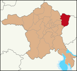
 Map showing Kalecik District in Ankara Province | |
| Coordinates: 40°05′50″N 33°24′30″E / 40.09722°N 33.40833°E | |
| Country | Turkey |
| Province | Ankara |
| Government | |
| • Mayor | Duhan Kalkan (AKP) |
| Area | 1,110 km2 (430 sq mi) |
| Elevation | 725 m (2,379 ft) |
| Population (2022)[1] | 12,794 |
| • Density | 12/km2 (30/sq mi) |
| Time zone | UTC+3 (TRT) |
| Postal code | 06870 |
| Area code | 0312 |
| Website | www |

Kalecik is a municipality and district of Ankara Province, Turkey.[2] Its area is 1,110 km2,[3] and its population is 12,794 (2022).[1] Its elevation is 725 m (2,379 ft).
Kalecik stands on a plain with the eastern boundary formed by the River Kızılırmak while there are mountains to the south and the west. This agricultural district is known for its wine; other major crops include sugar beet and grains.
The popular grape variety Kalecik Karası grows successfully near the Kızılırmak and is used to make some of Turkey's best red wine.
History
[edit]The area has a history going back to the Hittites and even never earlier (4000 BC). In the Ottoman Empire period this was a thriving town recorded by the 17th-century traveler Evliya Çelebi as being a trading city with tanneries, coppersmiths, and weavers.

Education
[edit]The vocational school of higher education in Kalecik (Turkish: Kalecik Meslek Yüksekokulu), part of Ankara University, educates in viticulture and winemaking.[4]
Places of interest
[edit]- Kalecik Castle, an Ancient Roman ruin on the rock above the town
- Kalecik Bridge
- Ottoman architecture, including a number of mosques and the seven-arch Develioğlu Köprüsü bridge over the Kızılırmak at 40°02′29″N 33°26′38″E / 40.0414°N 33.4440°E.
Composition
[edit]There are 57 neighbourhoods in Kalecik District:[5]
- Afşar
- Ahikemalşenyurt
- Ahiler Yenice
- Akcataş
- Akkaynak
- Akkuzulu
- Aktepe
- Alibeyli
- Altıntaş
- Arkbürk
- Beykavağı
- Buğra
- Çandır
- Çanşa Kale
- Çaykaya
- Çiftlikköy
- Cuma Saray
- Dağdemir
- Değirmenkaya
- Demirtaş
- Elmapınar
- Eskiköy
- Eşmedere
- Gökçeören
- Gökdere
- Gölköy
- Gümüşpınar
- Hacıköy
- Halilağa Tabakhane
- Halitcevriaslangil
- Hançılı
- Hasayaz
- Karahöyük
- Karalar
- Karatepe
- Kargın
- Keklicek
- Kılçak
- Kınık
- Kızılkaya
- Koyunbaba
- Kuyucak
- Mahmutlar
- Samanlık
- Satılar
- Şemsettin
- Şeyhmahmut
- Tavşancık
- Tilki
- Uyurca
- Yalımköy
- Yeniçöte
- Yenidoğan Yeşilyurt
- Yeşilöz
- Yılanlı
- Yurtyenice
- Yüzbey
References
[edit]- ^ a b "Address-based population registration system (ADNKS) results dated 31 December 2022, Favorite Reports" (XLS). TÜİK. Retrieved 22 May 2023.
- ^ Büyükşehir İlçe Belediyesi, Turkey Civil Administration Departments Inventory. Retrieved 8 June 2023.
- ^ "İl ve İlçe Yüz ölçümleri". General Directorate of Mapping. Retrieved 22 May 2023.
- ^ "Şarap Üretim Teknolojisi Programı" (in Turkish). Kalecik Meslek Yüksekokulu. Retrieved 2015-07-28.
- ^ Mahalle, Turkey Civil Administration Departments Inventory. Retrieved 22 May 2023.
External links
[edit]- Kalecik Tanıtım Gönüllüleri & www.kalecik.com.tr (in Turkish)
- Kenthaber.com. "General information on Kalecik, Ankara" (in Turkish). Archived from the original on 2008-10-11.


